6 Conclusions
6.1 The Impact of Spatial Configuration on Crime Types and Distribution
The research found that certain spatial configuration characteristics had relations with crime types. For example, the areas with low depth, high integration, and high connectivity recorded the least crimes, and crimes in these areas were basically littering. Spaces with medium depth, medium integration, and medium connection recorded criminal activities such as verbal harassment, vandalism, inappropriate behaviors, and littering. Serious criminal activities such as alcohol / drug abuse, public urination, and physical harassment took place mostly in spaces with high depth, minimal integration, and minimum connectivity. Most crimes against oneself did not occur in the paths or plazas but in the areas with low integration values.
Additionally, the entrance of the park attracted crimes like kidnapping and fights with pocket knives, as this area maximizes the probability of escaping. Moreover, site observation found that the park visitors prefer to sit near the park access, where pocket-picking crimes were mostly occurred. Table 4 shows the range of integration values for each crime type. The integration values of non-crime zones were relatively higher (up to 5.2), except for the entrance and the area near the administration that provided natural surveillance.
6.2 The Impact of Site Visibility on Crime Types andDistribution
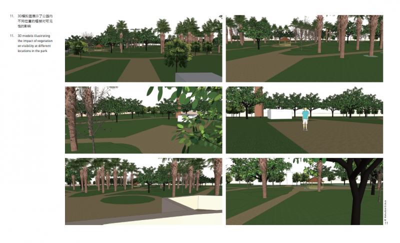
When comparing the park’s visibility graph with crime types and distribution, it was found that the more visible the area was, the fewer illegal actions occurred, e.g. the park center. The less visible area near the fence recorded alcohol / drug abuse incidents. Crimes against others, especially inappropriate behaviors, appeared in the low visible zones in the southwest and northeast sections. High and medium visible spaces occupied by crowds were prone to dangerous crimes against others, like thefts / pocket-pickings, and child kidnapping due to their proximity to the escape point (entrance). As for vandalism against the park, it occurred in medium to low visible areas and a few spots with high visibility. Table 5 summaries the visibility value ranges of areas for different crime types (average visibility value is 10,600). Figure 11
illustrates the impact of vegetation on sightlines in different locations in the park.
It can be concluded that the poor integration of the southern sections encouraged the crimes. Furthermore, the lack of a balance between shading trees for thermal comfort / visual appeal and high visibility compromised safety levels, particularly at the park periphery. The surveillance of the security team was concentrated at the entrance gate, and cannot cover the whole park visually. The locations of the entrance and the administration affected the crime distribution by offering natural surveillance, while crowd distribution had an impact on the appearance of some crime types.
7 Discussion
In the past 20 years, space syntax theory has been adopted to examine the relationship between the spatial configuration of urban contexts and human activity patterns / behaviors. In
this study, Rod El Farag Park situated in an informal district in Cairo City, Egypt, with a noticeable criminal records, was selected to investigate the effect of its spatial configuration on crime distribution and types. The results indicated a correlation between measurements as space connectivity / integration / depth and crime commitment. Deep, isolated spaces offered opportunities for drug use, inappropriate behaviors, and harassment. As for well-connected paths or areas that welcomed more people and hindered most crimes nevertheless offered the opportunity for thefts and armed fights. Crimes against the park (e.g. vandalism) did not associate with a specific integration level as it occurred all over the park except for the center. The finding about space depth supported the finding of Bill Hillier and Ozlem Sahbaz that less accessible segments (with more space depth) were associated with more robberies per unit of street length[24]. But some other studies held the opposite opinions: Irina Matijosaitiene’s study in New Haven, USA, and Kaunas, Lithuania[25] declared that more robberies happened in common use areas. Another study in Canada by Toby Davies and Shane Johnson concluded a higher risk of burglary for streets with more potential usage[18].
The results of this study also reveal the negative impact of the existing tree distribution and types on the sightlines, as they create blind spots for crime to hide. The evergreen buffer placed around the periphery deprived the park of natural surveillance from the streets around it. The use of deciduous trees enhanced the park’s visual connectivity in winter, while in summer, large, dense canopies of evergreen and deciduous trees obstructed the visibility to many zones. Crimes against oneself and (dangerous) crimes against others sought hiding places, while crimes against the park did not need such secrecy. This conclusion supports a study showing that places with higher accessibility / visibility tend to have lower crime rates[9]. Sean E. Michael, R. Bruce Hull, and Diane L. Zahm[26] discussed in their research on statements by local police that dense vegetation was used by criminals to hide or dispose unwanted goods. Nevertheless, this does not mean removing shrubs or trees, as parks need intimate private places and some mystery. Vegetation should be designed in such a way to ensure the visibility of the surroundings while performing its ornamental and shading functions. Meanwhile, this study has many limitations, one of which is failing to consider the impact of space uses on crimes, as the entrance, the administration, and the office provided some natural surveillance hindering most of the crimes.
Although space syntax has been widely used in research at the neighborhood or city scale, its site-scale implementation, such as open spaces and parks, is still very limited. This study proves that space syntax theory is able to predict the crime zones in urban parks in the Egyptian context. The results open the door to including safety simulations in the design stage of parks to improve the safety level as much as possible. More studies should be conducted to evaluate the method’s applicability in other regional contexts, preferably through utilizing 3D software for more accurate representation of the spatial configuration, and with parks accommodating various activities and attraction points.
6 结论
6.1 空间布局对犯罪类型及其分布的影响
研究发现,公园中犯罪类型与特定的空间布局相关。例如,空间深度小、整合度及连接度高的区域犯罪记录最少,且犯罪类型以乱抛垃圾为主;在空间深度、整合度与连接度均中等的区域发生的犯罪活动主要为言语骚扰、破坏公物、不雅行为和乱抛垃圾;空间深度大、整合度与连接度极低的区域最容易发生严重犯罪活动,如酗酒、吸毒、随地小便和肢体骚扰。大多数自我危害行为发生在空间整合度低的区域,而非道路或广场上。
此外,公园入口处更易发生绑架和持刀斗殴等犯罪活动,因为犯罪者逃脱的可能性相对较大。此外,现场观察结果表明,游客更喜欢坐在公园的入口和出口附近,这里的扒窃犯罪也更为多发。从表4所示的各类型犯罪发生场所的空间整合度数值范围可知,除入口区域和具有自然监视的公园管理处周边区域以外,无犯罪区域的整合度相对较高(可达5.2)。


6.2 场地可见性对犯罪类型和分布的影响
将公园的可见性分析图与犯罪类型及其分布图进行比较可知,空间可见性越高,发生非法行为的可能性就越小(如公园中心区域):围栏附近可见性较差的区域会发生酗酒、吸毒等事件;危害他人行为(尤其是不雅行为)多发生于公园西南部和东北部的低可见性区域;可见性中等或较高但人群密集的空间容易发生严重危害他人行为,如盗窃、扒窃和绑架儿童,因为这些地点邻近出入口,更便于犯罪者逃脱;危害公园行为则多发生在可见性中等及较低的区域,个别发生在高可见性区域。表5总结了不同犯罪类型发生区域所对应的可见度取值
范围(平均值为10 600)之间的关系,图11展示了公园内不同位置的植被对视线的影响。
综上,公园南部区域的低空间整合度助长了犯罪活动的发生。此外,遮阴植被虽然提升了公园的舒适度和视觉吸引力,但也带来了空间安全隐患,尤其是在公园外围地区。公园保安队伍的监视活动主要集中于入口区域,无法覆盖整个公园。作为自然监视的来源,公园入口和公园管理处的位置对犯罪行为的分布有明显影响,而人群分布则与特定类型的犯罪有关。

7 讨论
空间句法理论被用于研究城市环境空间布局与人类活动模式/行为之间的关系已有20余年的历史。本研究选择了位于埃及开罗市非正式聚居区且犯罪频发的REF公园为研究对象,探究了公园空间布局与在此发生的犯罪类型及空间分布的影响。结果表明,空间连接度、整合度、深度均与犯罪行为存在相关性。具有较大空间深度、与周边连接度较低的地点易发生吸毒、不雅行为和寻衅滋事等犯罪活动;连接度较高的道路及区域能吸引更多人群,有助于减少大多数的犯罪行为,却是盗窃和持械斗殴的易发场所。危害公园行为(如破坏公物)常见于除中心区域以外的任何区域,与空间整合度的关联性不明显。研究对空间深度的分析结果印证了比尔·希利尔和奥兹莱姆·萨巴兹的观点,即可达性差的街道(空间深度值较大)每单位长度发生的抢劫事件更多[24];但也有一些研究得出了相反的结论,如伊琳娜·马蒂诺塞汀在美国纽黑文市和立陶宛考纳斯市进行的研究表明,公共区域中抢劫案的发生率更高[25];托比·戴维斯和肖恩·约翰逊在加拿大进行的另一项研究也发现,潜在使用者更多的街道周边更易发生入室盗窃[18]。本研究还指出公园树木现状分布和类型对视线存在的负面影响,这些树木有可能成为犯罪者的藏身之处;公园四周种植的常绿乔木带使公园丧失了来自周边街道的自然监视;落叶乔木使得公园冬季的视线通透性较高,而在夏季,常绿和落叶乔木庞大、茂密的树冠则大大降低了许多区域的可见性。自我危害行为和(严重)危害他人行为的发生地点都具有一定的隐蔽性,而危害公园行为则多发于开阔场所,这与另一项研究的发现—可达性或可见性较高的场所犯罪率整体较低[9]—基本一致。席恩·E·迈克尔、R·布鲁斯·胡尔与戴安·L·扎姆[26]在对当地警察的陈述资料进行研究后,发现犯罪分子经常在植被茂密区域藏匿或处置赃物。但本研究并不建议公园对乔灌木进行清除(因为这类植被能为公园营造空间私密性和神秘感),而是倡导公园的种植设计应在考虑植物的观赏性与遮阴功能的同时,也能够保障周围环境的可见性。需要指出的是,本研究存在许多局限性,其中之一是未考虑空间使用对犯罪的影响,因为入口和管理区域在一定程度上提供了自然监视,从而预防了大多数犯罪行为的发生。尽管空间句法已被广泛运用于邻里及城市尺度的研究,其在开放空间和公园等场地尺度研究中的应用仍然非常有限。本研究证明了运用空间句法理论预测埃及城市公园内犯罪发生区域的可行性,鼓励在公园设计阶段即引入安全性模拟分析,从而最大限度地提高公园安全性。未来还需进一步探究本研究方法在其他地域背景下的适用性,运用3D软件对空间布局进行更准确的模拟;在研究对象方面,应对活动及设施类型更多样、更具吸引力的公园予以更多关注。


 发表于 2021-12-24 14:44
 收藏
收藏  支持
支持  反对
反对  回复
回复 呼我
呼我