账号:
自动登录
密码:

浏览:632   回复:20

规划班居住区设计组—参考文献翻译 [复制链接]

  • 参与勋章

    研究勋章

    互助勋章

11楼  发表于 2021-12-01 17:50

第2个重要的量化数据是空间明显性,也被称为空间智慧化,即空间形态是否能够让使用者很快地理解的量化指标。这个空间特质是由整体便捷值与连接值之间的关联性呈现。集美大社的空间明显性相当的低,只有0.1655,这样的结果反应了集美大社的不规则整体聚落空间形态。对于外来者而言,集美大社的错综复杂巷弄使得首次到访的使用者很难掌握方向感,不知道自己身处何处,使用者因此如同置身于迷宫之中。不明显的空间组织有利于提升居民的安全感,同时吸引外来者探索聚落的空间特质。

The second important quantitative data is spatial saliency, also known as spatial intelligence, which means whether the spatial form can be understood by users quickly. This spatial trait is presented by the correlation between the global integration value and the connection value. The spatial significance of Jimei Dashe is quite low, only 0.1655. This result reflects the irregular global village spatial form of Jimei Dashe. For outsiders, the intricate lanes of Jimei Dashe make it difficult for first-time visitors to grasp the sense of direction and do not know where they are. Therefore, users are like in a maze. The less obvious spatial organization is conducive to improving the residents' sense of security and attracting outsiders to explore the spatial characteristics of the village.

  • 参与勋章

    研究勋章

    互助勋章

12楼  发表于 2021-12-01 17:52

第2个重要的量化数据是空间明显性,也被称为空间智慧化,即空间形态是否能够让使用者很快地理解的量化指标。这个空间特质是由整体便捷值与连接值之间的关联性呈现。集美大社的空间明显性相当的低,只有0.1655,这样的结果反应了集美大社的不规则整体聚落空间形态。对于外来者而言,集美大社的错综复杂巷弄使得首次到访的使用者很难掌握方向感,不知道自己身处何处,使用者因此如同置身于迷宫之中。不明显的空间组织有利于提升居民的安全感,同时吸引外来者探索聚落的空间特质。

The second important quantitative data is spatial saliency, also known as spatial intelligence, which means whether the spatial form can be understood by users quickly. This spatial trait is presented by the correlation between the global integration value and the connection value. The spatial significance of Jimei Dashe is quite low, only 0.1655. This result reflects the irregular global village spatial form of Jimei Dashe. For outsiders, the intricate lanes of Jimei Dashe make it difficult for first-time visitors to grasp the sense of direction and do not know where they are. Therefore, users are like in a maze. The less obvious spatial organization is conducive to improving the residents' sense of security and attracting outsiders to explore the spatial characteristics of the village.

  • 参与勋章

    研究勋章

    互助勋章

13楼  发表于 2021-12-25 21:58

Integration[HH] refers to the total number of topology steps required to get from one node to other nodes after excluding all factors. The higher the integration degree is, the fewer the number of expansion steps, the warmer the color of axis, the lower the dispersion degree of space, and the greater the possibility of traffic arrival, and vice versa. Integration degree includes global integration degree and local integration degree. The former reflects the relationship between a unit space and all global Spaces, and can reflect the global space center. It studies the possibility of vehicle travelers reaching other Spaces from each space. Integration[HH] refers to the degree of Integration between a space unit and the local space within a few steps from it. It refers to the total number of topological steps required from a node to other nodes after removing all the influencing factors in topology. The higher the integration degree is, the fewer the number of expansion steps, the warmer the color of axis, the lower the dispersion degree of space, and the greater the possibility of traffic arrival, and vice versa. Integration degree includes global integration degree and local integration degree. The former reflects the relationship between a unit space and all global Spaces, and can reflect the global space center. It studies the possibility of vehicle travelers reaching other Spaces from each space. The latter refers to a space unit and the local space within a few steps from it.

整合度(Integration[HH])即集成度,是指 剔除拓扑学上所有影响因素后,从某一节点到 其余节点所需要的总拓扑步数。整合度越高,拓 扑步数越少,轴线颜色越暖,空间的离散程度越 低,作为交通到达(to-movement)的可能性更 大,反之亦然。整合度包含全局整合度与局部整 合度,前者体现了某个单元空间与全局所有空间 的关系,可反映全局的空间中心,研究的是车行 出行者从每一个空间到达其他空间的可能性 ; 后 者指某空间单元与距它几步范围内的局部空间之整合度(Integration[HH])即集成度,是指 剔除拓扑学上所有影响因素后,从某一节点到 其余节点所需要的总拓扑步数。整合度越高,拓 扑步数越少,轴线颜色越暖,空间的离散程度越 低,作为交通到达(to-movement)的可能性更 大,反之亦然。整合度包含全局整合度与局部整 合度,前者体现了某个单元空间与全局所有空间 的关系,可反映全局的空间中心,研究的是车行 出行者从每一个空间到达其他空间的可能性 ; 后 者指某空间单元与距它几步范围内的局部空间之

  • 参与勋章

    研究勋章

    互助勋章

14楼  发表于 2021-12-25 21:59

Hillier and his team found a close relationship between comprehensibility and spatial integration and connection value after a large number of experiments, that is, local space and global space must be correlated to a certain extent. The greater the correlation, the higher the coincidence between the locally perceptible space and the overall invisible space. Therefore, spatial form is easier to be understood by people [12]. Comprehensibility explores the relationship between global Integration and local Integration, and is calculated by the following formula: Comprehensibility = topology radius 3 Integration (Integration[HH]R3)/Integration[HH] infinite topology radius. According to the scatter diagram of FAW comprehensibility (FIG.5), the value of comprehensibility is greater than 0.5, indicating that the entire spatial structure is easy to be perceived by users. Thanks to the grid road layout, the space is easy to be understood. But at the same time, the residential courtyards in the living area repeat the same layout, reducing the interest of the space.

希利尔及其团队经过大量实验验证后发现, 可理解度与空间整合度及连接值的关系密切,即 局部空间与全局空间必然存在着一定程度上的相 关性,相关性越大,则意味着局部可感知空间与 整体不可见空间的吻合性越高,因此空间形态更 容易被人们所理解[12]。可理解度探究的是全局整 合度与局部整合度之间的关系,其计算公式 : 可 理解度=拓扑半径3整合度(Integration[HH]R3) /无限拓扑半径整合度(Integration[HH])。从一 汽可理解度散点图(图5)来看, 可理解度数值大 于0.5,说明整个空间结构易于被使用者感知,这 得益于网格状道路布局,使空间易于被理解。但 与此同时,生活区住宅院落重复着相同的布局, 减少了空间的趣味性。

  • 参与勋章

    研究勋章

    互助勋章

15楼  发表于 2021-12-25 22:01

From the perspective of global integration degree (FIG. 1), FAW Block is the area with the highest integration degree of the whole axle line system, and it is highly possible for drivers to reach the selected area. Among them, the urban trunk roads (Dongfeng Street, Jincheng Street, Chuangye Street) and the kuanping road connecting the southern area have the highest values, which are the optimal road axis of accessibility. On the whole, the average global integration degree of the northern region of the axis model is higher than that of the southern region, which may be due to the division of railway, leading to the separation of spatial functions. According to the analysis of local integration degree (R=3) (Figure 2), it can be seen that the integration degree of main urban arterial roads has been significantly enhanced, and that of local secondary arterial roads has also been improved, but the average local integration degree of FAW block is always the highest. While the integration degree of faW production area is improving, the integration degree of roads in living area is declining, and the possibility of reaching traffic by foot is low. According to the field survey, the users of the public space in the living area are the elderly who live here, and there are fewer outsiders to participate in the public space, which is consistent with the result of space syntax calculation. The reason for this problem is that the enclosed housing in the living area clearly defines the spatial boundary. Although it has strong privacy, the accessibility inside the courtyard is reduced, while the roads between the courtyard show good accessibility.

从全局整合度(图1)来看,一汽街区是全轴 线系统整合度最高区域,作为车行者交通到达选 择区域的可能性很高。其中,生活区内城市干道 (东风大街、锦程大街、创业大街)和连接南部 区域的宽平大路数值最高,为可达性最优道路轴 线。从整体来看,轴线模型北部区域比南部区域 平均全局整合度高,可能是由于铁路的分割,导 致了空间功能的割裂。 根据局部整合度(R=3)的分析(图2)可 知,主要城市干道的整合度有明显增强,局部次 干道的整合度也有所提升,但始终是一汽街区的 平均局部整合度最高。一汽生产区整合度提升的 同时,生活区内部道路的整合度却呈下降趋势, 作为步行到达交通的可能性较低。 根据实地调研,生活区公共空间使用者为 在此居住的老年人,较少外来人参与,使用者较 少,这与空间句法计算结果相统一。该问题是由 于生活区的围合式住宅明确界定了空间边界,虽有 较强的私密性,但导致了院落内部可达性降低,院 落之间的道路却呈现出通达性良好的状态。

  • 参与勋章

    研究勋章

    互助勋章

16楼  发表于 2021-12-25 22:02

based on the functional analysis of spatial regions, it can be seen that Dongfeng Dajie plays an important role in the whole axis system. It connects the coupling in spatial form, but in actual spatial structure, it is mutually independent faW living area and production area. Therefore, Dongfeng Dajie is taken as the selection set for topological in-depth analysis (FIG. 4). Explore the topological steps required by other road axes to reach Dongfeng Street. The colder the color, the fewer topological steps required, and the easier it is to reach. It can be seen from Figure 8 that the topological depth of the area to the north of the railway is much lower than that of the area to the south of the railway, which is consistent with the integration analysis results. Under the segmentation of the axis system by the railway, not only the regional functions are separated, but also the spatial structure is deconstructed. Therefore, attention should be paid to the area to the north of the railway. According to the analysis results, the topological steps of main roads in faW production area and living area are very low, but the topological depth of fragmentary roads south of residential yards in living area and No. 6 Road in production area is very deep. The former is due to the added complexity of the enclosed courtyard housing, the latter to the interior of the production area

基于空间区域功能分析可知,东风大街在整 个轴线系统中占有很重要的地位,其连通了在空 间形态上的耦合,但在实际空间结构上却是相互 独立的一汽生活区与生产区,因此以东风大街作 为选择集进行拓扑深度分析(图4),探究其他道 路轴线到达东风大街所需要的拓扑步数,颜色越 冷,所需拓扑步数越少,则越容易到达。由图8可 以看出,铁路以北区域的拓扑深度远低于铁路以 南区域,这与整合度分析结果相一致,轴线系统 在铁路的分割下,不仅区域功能产生了割裂,空 间结构也出现了解构现象,因此应将关注点着重 于铁路以北区域。从分析结果来看,一汽生产区 与生活区的主要干道拓扑步数都很低,但生活区 住宅院落与生产区6号路以南的零碎道路拓扑深度 很大。前者是由于围合式院落住宅增加了空间的 复杂性,后者是由于生产区内部

  • 参与勋章

    研究勋章

    互助勋章

17楼  发表于 2021-12-25 22:24   楼主

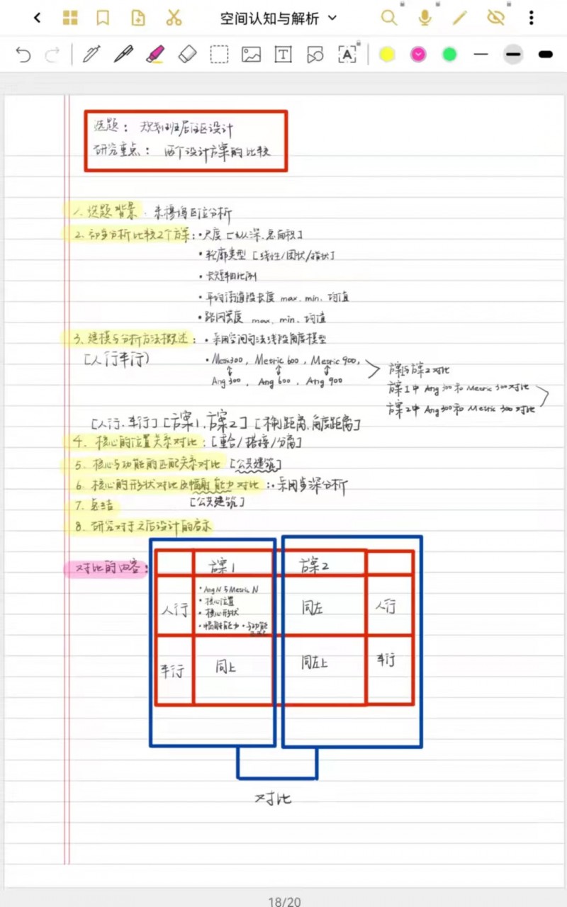
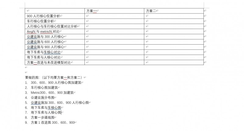
课程记录:由于我们组的重点是两个设计方案的对比,所以围绕这个中心做出以下提纲与表格

  • 参与勋章

    研究勋章

    互助勋章

18楼  发表于 2021-12-25 22:40   楼主

翻译:

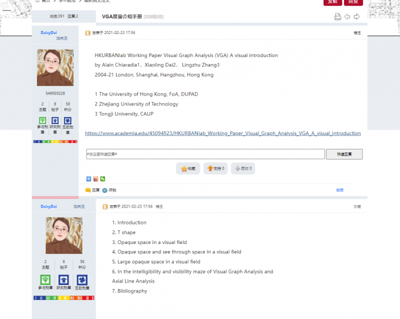
HKURBANlab 工作文件 视觉图分析 (VGA) 视觉介绍

作者:Alain Chiaradia1,戴晓玲2,张玲珠3

2004-21 伦敦、上海、杭州、香港


1 香港大学,FoA,DUPAD

2 浙江工业大学

3到同济大学


https://www.academia.edu/45094923/HKURBANlab_Working_Paper_Visual_Graph_Analysis_VGA_A_visual_introduction

1. 引言

2. T

3. 视野中的不透明空间

4. 不透明的空间,在视野中看穿空间

5. 视野中大不透明空间

6. 在可视化图形分析和的可理解性和可见性迷宫中

轴向线分析

7. 参考书目


  • 参与勋章

    研究勋章

    互助勋章

19楼  发表于 2021-12-26 02:21   楼主

2. PROBLEMATISATION

This section aims to discuss the outcomes of the previous applications of space syntax segment analysis to Rio de Janeiro (Hillier et al., 2012; Krenz et al., 2015). The purpose is to highlight their critical points concerning the object of this study, i.e., the connections between favelas and the global city's network. By this means, this section relates the hypothesis and conclusions of the analyses mentioned above with the argumentations of two extensive urban studies of Rio de Janeiro, i.e., Abreu's history of the urban evolution (1987; 1994) and Perlman's forty-years-based ethnology on Rio's favelas (2010).

2.问题

本节旨在讨论先前在里约热内卢应用空间句法片段分析的结果(Hillier等,2012; Krenz等,2015)。 目的是突出他们关于本研究目标的关键点,即贫民窟与全球城市网络之间的联系。 通过这种方式,本节将上述分析的假设和结论与里约热内卢的两项广泛的城市研究的论点联系起来,即阿布鲁乌的城市演变史(1987年; 1994年)和佩尔曼基于四十年的民族学 在里约热内卢的贫民窟(2010)。

The main points we discuss here are the following: the historical and economic relation between the residential background and foreground and, by which means, this relation causes different levels of marginalisation between the favelas and the urban system as a whole.

我们在这里讨论的要点如下:居住背景和前景之间的历史和经济关系,并通过这种关系在贫民窟和整个城市系统之间造成不同程度的边缘化。


  • 参与勋章

    研究勋章

    互助勋章

20楼  发表于 2021-12-26 02:22   楼主

On the contrary, the analyses of Istanbul and Rio present stronger local backgrounds, lacking global-to-local structures. The authors suggest a possible explanation for this kind of structure. That is the rapid residential growth led the construction of the city, by subordinating the economic logic of the foreground to the social logic of the background.

相反,对伊斯坦布尔和里约热内卢的分析具有较强的地方背景,缺乏全球对地方的结构。 作者提出了这种结构的可能解释。 那就是通过将前景的经济逻辑从属于背景的社会逻辑,快速的住宅增长引领了城市的建设。


 «上一页   1   2   下一页»   共20条/2页 
网站指南